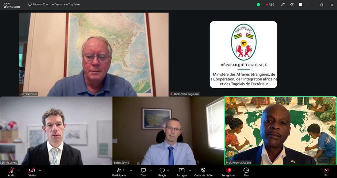
The debate over how the world is represented on a map has entered a new phase. Following the adoption by the United Nations General Assembly of the “Correct the Map” resolution, the three cartographers behind the Equal Earth projection Tom Patterson, Bernhard Jenny and Bojan Šavrič have agreed to provide scientific and technical support to Togo and the African Union as the initiative moves from advocacy to implementation.
The commitment was announced following a virtual meeting on 20 September 2026 convened at the initiative of Professor Robert Dussey, Togo’s Minister of Foreign Affairs, who championed the initiative at the United Nations on behalf of the African Group. The General Assembly adopted the resolution on 4 September by 164 votes in favour, with one vote against and six abstentions. The development gives a scientific dimension to what has become an important African diplomatic initiative: ensuring that the physical size of the world’s regions is represented more accurately in maps used for education, public communication and international affairs.
Equal Earth was developed in 2018 by Patterson, Jenny and Šavrič as an equal-area world map projection designed to preserve the relative size of land areas while maintaining a recognisable appearance of the continents. Its significance lies partly in what it does what it does not claim to do.
No flat map can reproduce the Earth’s curved surface without some form of distortion. Different projections therefore make different compromises involving area, shape, distance or direction. Equal Earth was specifically designed to prioritise the accurate representation of relative land area.
The projection was published in the International Journal of Geographical Information Science in 2018 and subsequently found applications in mapping and scientific contexts, including NASA’s Goddard Institute for Space Studies and Esri software.
Its relevance to the African initiative is straightforward: Africa’s enormous geographic area is visually understated in commonly encountered world maps based on projections designed for other purposes, particularly the Mercator projection. The African Union has subsequently supported Equal Earth as an institutional cartographic reference, giving the projection a continental policy dimension.
The diplomatic breakthrough came on 4 September 2026, when the UN General Assembly adopted resolution A/RES/80/307, titled “Correct the map: rebalancing global cartographic representation and promoting equitable representation of the world’s regions, particularly Africa.” The initiative was introduced by Togo on behalf of the African Group and supported by the African Union. The adopted resolution encourages governments, schools, international organisations, publishers and technology companies to make greater use of equal-area projections where the relative size of territories is important.
Importantly, the resolution does not establish a universal ban on the Mercator projection, nor does it require every map to use Equal Earth. Different map projections serve different purposes. Mercator, for example, was developed principally for navigation and has properties that make it useful for that function. Equal Earth addresses a different cartographic priority: representing the relative area of continents and countries more faithfully. As the designers themselves have emphasised, there is no single projection that can eliminate every form of distortion. The UN initiative is therefore better understood as an effort to broaden cartographic choices and improve geographical literacy rather than simply replacing one map with another.
The decision by the Equal Earth designers to participate in the implementation phase creates an unusual bridge between scientific expertise and multilateral diplomacy. During the 20 September meeting, discussions reportedly focused on three principal areas of cooperation: providing scientific and technical assistance to governments and institutions adopting equal-area projections; developing freely usable reference maps; and preparing educational resources for African school systems. These priorities shift the initiative from symbolism to practical implementation.
A resolution adopted in New York can establish international encouragement. But changing the maps used in classrooms, textbooks, digital platforms and institutional publications requires technical standards, accessible materials, teacher resources and sustained coordination. That is where the involvement of the projection’s original designers becomes particularly significant.
The most consequential element of the initiative may ultimately be educational. For generations, students around the world have encountered maps as seemingly objective representations of geographic reality. Yet every world map is a projection of a three-dimensional planet onto a two-dimensional surface. Choices about what to preserve inevitably affect what viewers perceive.
The African initiative places this cartographic literacy within a broader question of how young people understand their continent and its place in the world. Professor Dussey described the educational dimension in terms of “cognitive justice,” arguing that how children learn to locate and visualise their continent can influence how they perceive the world.
The proposed cooperation therefore goes beyond printing new maps. It raises the possibility of developing teaching materials that explain why maps differ, what each projection is designed to achieve, and why no two-dimensional representation can perfectly reproduce the Earth. Such an approach would make the initiative educational rather than merely symbolic.
Togo is now expected to develop a concept note for a scientific advisory group that would provide a structured framework for the implementation process. The three Equal Earth designers have been invited to participate in their personal capacities.
A scientific advisory mechanism could help address some of the practical questions that arise from the resolution: which equal-area projections are appropriate for particular uses; how reference maps should be produced; how educational materials should be standardised; and how institutions can explain the limitations of different projections. It could also help preserve an important principle at the heart of the initiative: cartographic decisions should remain grounded in geographic science.
African diplomacy at the United Nations frequently focuses on questions of peace and security, development, climate change, trade, financing and reform of international institutions. “Correct the Map” introduces another dimension: the politics and science of representation. The African Union’s support and Togo’s diplomatic leadership demonstrate how a technical subject can become part of multilateral diplomacy when it intersects with questions of representation and international perception.
The initiative also illustrates how scientific work developed independently of political campaigning can later acquire international policy relevance. The Equal Earth designers did not originally create their projection as a diplomatic instrument. Its subsequent adoption and advocacy have given the work a new institutional context. That distinction is important because it allows the scientific contribution and the diplomatic objective to reinforce one another without confusing their respective roles.
Although Africa is central to the campaign, the UN resolution has a wider geographical scope. The underlying issue is not exclusively about Africa. It concerns how the relative size of all regions is communicated through maps and how institutions select projections according to their intended purpose. The resolution consequently encourages a broader conversation about geographical literacy and representation.
For schools, the implication may be particularly significant: students could encounter multiple projections and learn to understand the choices behind them rather than assuming that one world map represents the Earth without distortion.For digital platforms and international organisations, the discussion raises another practical question whether different cartographic projections should be selected according to the information a map is intended to communicate.
The adoption of the “Correct the Map” resolution was a diplomatic milestone. The next phase will be considerably more practical. Governments and institutions will have to determine whether and where to incorporate equal-area projections. Educational authorities will need appropriate materials. Cartographers and geospatial specialists will need to support implementation. Technology companies and publishers will have to consider how projection choices affect their products and audiences.
The proposed scientific advisory group could become an important mechanism for coordinating these efforts. The involvement of Patterson, Jenny and Šavrič provides an additional connection between the original scientific work and the international policy process now developing around it. For Africa, the significance extends beyond the appearance of a continent on a classroom wall.
It is about whether geographic representation can be made more scientifically accurate, whether students can be equipped to understand the limitations of maps, and whether international institutions can become more deliberate about the visual language through which the world is represented.
A map does not change the physical size of a continent but the choice of projection can change how that size is perceived. The next chapter of “Correct the Map” will therefore not be written primarily in a UN voting hall. It will be written in classrooms, atlases, digital platforms, government institutions and reference materials around the world.That is where a diplomatic resolution becomes practical knowledge—and where a cartographic debate can become part of how future generations understand the world.